Short answer: A location intelligence consultant turns a where-based business or planning question into a documented GIS analysis, then delivers maps, ranked options, data, and recommendations that decision-makers can review.
Many decisions have a location problem hiding inside them. Where should a facility go? Which parcels are most suitable? Who is inside a service area? Where are access gaps, constraints, risks, or opportunities? Location analysis consulting helps turn those questions into a spatial method that people can see, review, and use.
What location analysis consulting means
Location analysis consulting is the process of using GIS data and spatial analysis to answer where-based questions. The work can include gathering source data, cleaning layers, comparing locations, mapping constraints, measuring access, scoring opportunities, and preparing outputs that support planning or operational decisions.
The final product is usually more than a map. It might be a ranked site list, a service area summary, a suitability model, a constraints map, a dashboard, or a documented GIS method that can be updated later. For service-specific support, CartoCodeGIS offers location analysis consulting and broader spatial analysis consulting.
Common questions location analysis can answer
- Which site, parcel, corridor, or area is the best fit?
- Who is served by a facility, asset, route, or program?
- Where are service gaps, access barriers, or overlapping needs?
- Which constraints could affect a project before it moves forward?
- Where do environmental, infrastructure, ownership, or zoning factors overlap?
- Which locations should be prioritized for field review or investment?
Location analysis consulting examples
Common location analysis consulting projects include site selection, service area analysis, access-gap mapping, constraint review, route and corridor comparison, asset prioritization, and opportunity scoring. These projects usually combine data cleanup, spatial analysis, clear maps, and a documented method stakeholders can review.
What a location intelligence consultant delivers
The deliverable should match the decision, not stop at a generic map. A site-selection project may produce a ranked parcel table, constraint flags, coverage measures, a shortlist map, and a methods note. A service-area project may produce drive-time areas, population or asset summaries, gap maps, comparison tables, and GIS layers that can be updated when facilities or source data change.
- Decision-ready maps for technical and non-technical reviewers.
- Ranked sites, service areas, routes, assets, or opportunity zones.
- GIS-ready data with clear field definitions and source notes.
- Methods documentation covering assumptions, scoring, and limitations.
- Recommendations for field verification or additional due diligence.
Who hires a location analysis consultant?
Local governments, utilities, nonprofits, developers, site selectors, infrastructure teams, field operations groups, and growing businesses use location analysis when geography affects cost, access, coverage, risk, or public impact. The work is especially valuable when several stakeholders need to understand why one location, route, or investment was prioritized over another.
Site selection and service-area analysis
Site selection compares candidate locations against mandatory requirements and preferred conditions such as zoning, parcel size, utilities, travel time, hazards, demographics, and proximity to existing assets. Service-area analysis starts from a facility, route, or network and measures who or what can realistically be reached.
Both methods work best when the criteria, data dates, coordinate systems, units, and missing values are explicit. This keeps the result useful for screening while leaving zoning confirmation, engineering, ownership, and field verification to the appropriate next steps.
Demonstration: screening parcels for a service facility
Suppose a planning team needs a shortlist of parcels for a new service facility. The question is which locations could improve coverage while meeting land-use, access, and infrastructure requirements. This is an illustrative workflow, not a completed client project or a recommendation about the parcels pictured below.
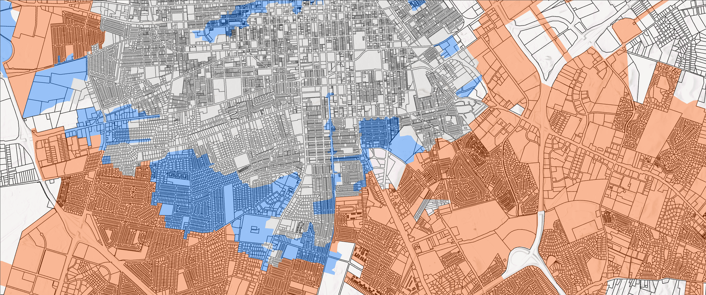
Inputs: parcel IDs and boundaries, zoning and permitted uses, existing facilities, roads, utility availability, relevant hazard layers, and the population or assets the facility would serve. Record each source, its date, and any gaps before comparing candidates.
- Agree on mandatory requirements, such as permitted use and minimum site area, separately from preferences such as shorter travel times.
- Align coordinate systems, check parcel IDs and geometry, and flag missing attributes rather than treating them as favorable conditions.
- Overlay parcels with constraints and coverage layers. Measure affected area and distinguish partial intersections from whole-parcel exclusions.
- Compare access using a road-network travel-time method when travel time matters. A straight-line buffer is only a proximity screen.
- Rank eligible candidates against agreed criteria, then vary any weights to see whether the shortlist changes.
- Send shortlisted parcels for zoning, utility, ownership, and field verification before making a final selection.
Outputs and decision: a candidate table with eligibility, constraint flags, coverage measures, and reasons for each ranking; a map of the shortlist; and a methods note. Together these help the team choose which sites deserve further investigation, rather than implying the map alone proves a site is feasible. Explore our site selection and service-area analysis services or browse other GIS project examples.
What goes into a location analysis project
A useful location analysis project starts by defining the decision. Before opening GIS software, it helps to clarify what the analysis needs to support, who will use it, which factors matter, and what data can be trusted.
From there, the work usually moves through data review, layer cleanup, spatial processing, quality checks, map design, and explanation. If a method uses weighted criteria, buffers, overlays, drive-time areas, or scoring, those assumptions should be documented so stakeholders can understand how the result was created.
Examples of location analysis consulting
Site suitability analysis is one common example. A team may need to compare candidate parcels using access, utilities, land use, hazards, zoning, nearby assets, or service coverage. GIS can bring those factors together so tradeoffs are easier to see.
Service area analysis is another example. A utility, public agency, nonprofit, or field team may need to understand who is reached by existing assets, where gaps exist, or how travel time and distance affect coverage.
Constraints and opportunity mapping can also help teams avoid surprises by showing where environmental limitations, infrastructure needs, ownership patterns, or operational concerns overlap.
Why the method matters as much as the map
A map can make a pattern visible, but the method behind the map is what makes the result defensible. Stakeholders need to know which data was used, which assumptions were made, and how the analysis connects to the final recommendation.
That is why good location analysis consulting focuses on both the visual output and the underlying workflow. The goal is a decision-ready product that can be explained, updated, and trusted.
When location analysis is worth doing
Location analysis is worth doing when a decision depends on geography, access, distance, service coverage, site conditions, spatial relationships, or competing constraints. It is especially useful when the answer needs to be shown to technical and non-technical audiences.
If a decision has a meaningful “where” component, GIS analysis can help organize the evidence and make the tradeoffs easier to discuss.
If the method needs to be repeated with new data, location analysis can also connect to GIS workflow automation so future updates are easier to maintain.
How CartoCodeGIS can help
CartoCodeGIS helps teams use location analysis for site suitability, service areas, route and access review, constraints mapping, opportunity scoring, public planning maps, and decision-ready spatial analysis. The focus is practical: clear methods, clean outputs, and maps that help people act.
Review the full list of location intelligence consulting services or see how repeatable methods connect to a mature GIS workflow.
Need to compare places or explain a location-based decision?
CartoCodeGIS can help turn the question into a clear analysis method, useful map products, and outputs your team can review.
Explore Location Analysis Consulting